Features
Offroad navigation, built for the trail.
Maps & terrain
Switch between OpenStreetMap, satellite and topographic base maps. A trail-difficulty colour overlay grades tracks from easy to extreme, and a rich POI layer shows camping, water, fuel, service, hospitals and viewpoints. Download any region for full offline use.
Recording & navigation
Record GPS tracks in the background with the screen off — a persistent notification keeps it visible and stoppable. Plan routes manually or point-to-point with turn-by-turn voice cues and off-track alerts. Import and export GPX so your routes are always yours.
3D map in the browser
The web version renders real elevation under satellite or topo imagery — tilt and turn the mountains, no install. It is the same account and the same cloud routes as the phone app, so you can plan on a big screen at home and ride it in the car the next morning.
Route planner
Click a few points and the route snaps to real tracks, not to the highway: 4×4, enduro, MTB and road profiles, surface split (paved / gravel / dirt), elevation, climb and a difficulty score — all live as you draw. Generate a loop of a given length from one starting point, import a GPX to analyse it, or re-optimise an existing track. Export as GPX or send it straight to the app.
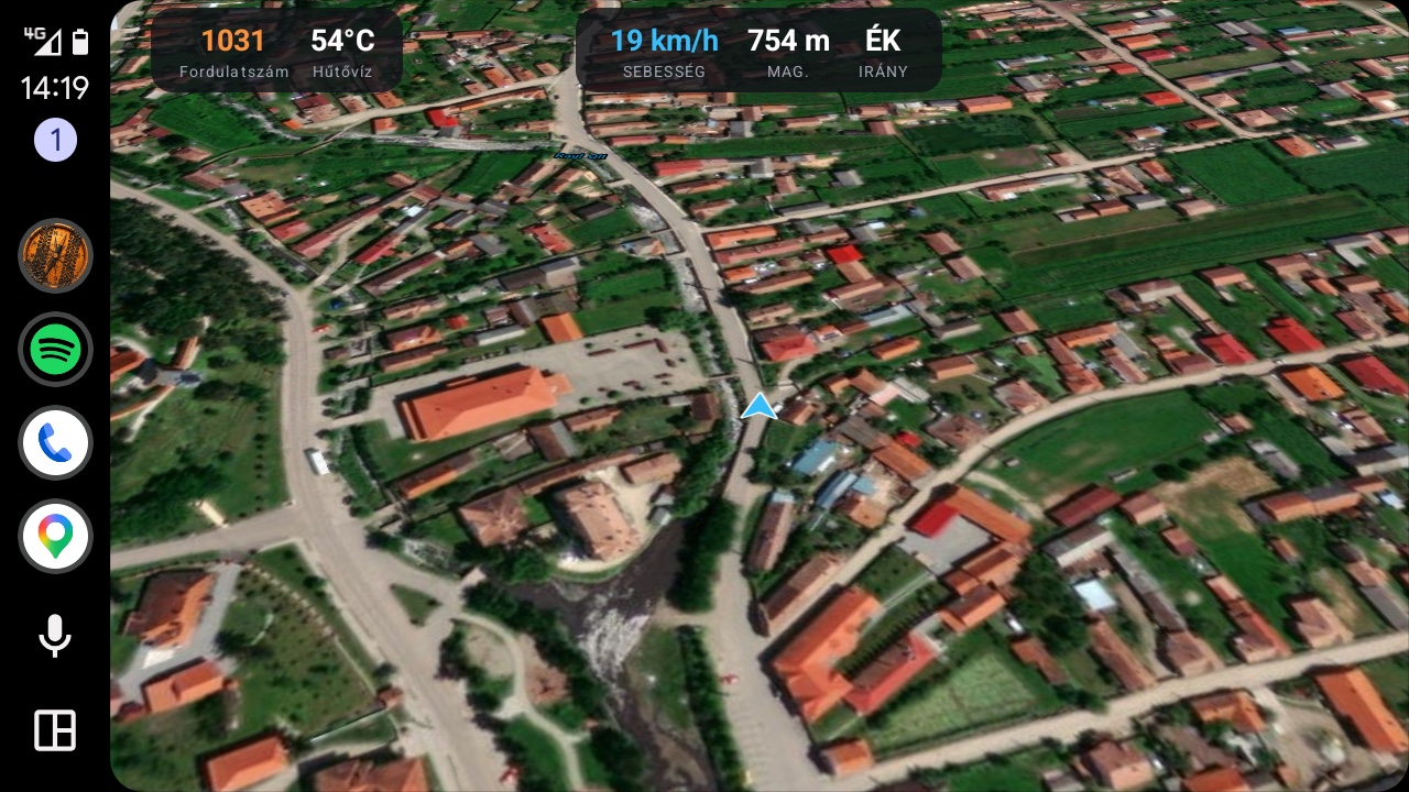
Android Auto — the map on your car screen
DirtMap runs on your car's display: offline topo or satellite maps in 3D, turn-by-turn guidance on your saved routes, live convoy positions, OBD gauges on the map and even track recording — all driven from the head unit. It starts with the car even if the phone never leaves your pocket, and switches between day and night mode automatically. CarPlay is on the way.
Convoy & walkie-talkie
Lead or join a convoy and see everyone's live position on the map. Participants follow the leader's trail from their own position forward. Push-to-Talk voice messages reach the whole group without phone calls, and play over Android Auto (CarPlay coming). Invite members with a link or QR code.
Routes, folders & sharing
Organise your saved routes into colour-coded folders, and share a single route or a whole folder with another DirtMap user by email — anything you later add to a shared folder shows up for them automatically. Manage and revoke shares any time.
3D replay (Premium recording)
All-day recording captures geotagged photos and clips along the way — saved even with no signal. Any day then replays over real 3D terrain in your browser: the camera follows the track, an elevation profile runs underneath and your photos pop up where you took them. One button exports the whole thing as a shareable video. The same player replays a convoy or a whole competition, every participant at their own recorded pace.
Area survey (Premium)
Walk the boundary of a plot and DirtMap saves it as a polygon and calculates the area in m² / hectares — useful for land, base camps, parking and hunting grounds.
Vehicle & OBD-II
Pair a Bluetooth OBD-II adapter to read live speed, RPM, coolant temperature, battery voltage and fault codes (DTC). Manage your vehicles and get reminders before inspection, insurance or tax expire.
Weather & rain radar
Overlay a live rain radar on the map and get weather alerts for your current area, so you can read the sky before it reads you.
Private by design
Your data lives on our European backend — never sold, never shared with advertisers. Delete your account and all data in one tap, and export your routes as GPX any time.
Competitions (for organizers)
Run your own offroad event from your phone: roadbook navigation, checkpoints, vehicle categories, a live leaderboard and an SOS button for participants. Drivers just join and follow — your first event is free.